
All tour information is user generated and although we try our best, we cannot guarantee its correctness. Always consult people with knowledge about the area and get a proper map. If in doubt, hire a guide!
Sass Pordoi - Standard route
Follow the tracks east from the cablecar station until you get down in the saddle with a refugio. From there head south down the steep slope usually filled with moguls. After a while it widens and offers a wide range of possibilities on the way back to the cablecar station. Quite steep after the refugio, but after that it gets easier.
The closest ski resort is Canazei - Belvedere
,
2 km away.
- Created by: Robert Johansson
- Difficulty: S4 - Difficult (<45°)
- Danger/Exposure: E1 - Low
- Time: 00:30 hours
- Total climb: 12 m
- Total elevation drop: 689 m
- Length: 2.01 km
- Highest altitude: 2924 m
- Lowest altitude: 2239 m
- Slope facing: S
- Extra gear: None
- Lift access: Yes
Photos
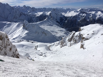
After the steepest part. You can see the cablecar-station down below-
Map
Public runs
No public runs yet.Elevation
Loading...
Slope
Loading...
Negative slope values means the track is heading uphill.